
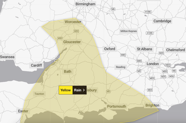
A MET Office warning for heavy rain across the Wellington and Backdown Hills areas was set to ease on Monday evening (December 4).
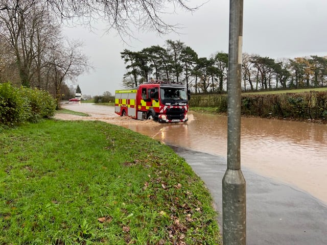
But not before many roads in and around the town once again became flooded, resulting in emergency services being stretched almost to full capacity.
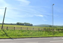
Flooding near Willowbrook garden Centre on the A38.
 Protect Wellington group declares opposition to Pegasus countryside housing proposal
 Warning issued for whole of Christmas Day as strong winds set to hit Westcountry
 Wellington man dies in hospital 13 days after woman's attempted murder arrest
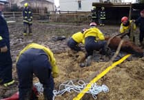 Wellington among three fire crews working to free horse trapped in farm slurry pit
Wellington Relief Road, which has become notorious for flooding in recent years, was under water in several places and blocked most traffic as only heavy lorries could get through.
An electricity sub-station in the Burrough Way area was briefly threatened as a culvert overflowed to within inches, but the water quickly subsided.
+ 4
(View All)
Emergency services were at full stretch on Monday as heavy rain again saw floods strike the Wellington area.
And the junction of Middle Green Road with the A38 was heavily under water and impassable with Somerset Council teams working hard to unblock drains.
Wellington Weekly reader Frank Sherlock said drains at the junction had become blocked by the huge amount of leaves falling from oak trees.
The A38 between Wellington and Taunton was under several inches of water in a number of places, causing long tailbacks of vehicles and disrupting the No 22 First Bus service between the towns.
The Willowbrook Garden Centre site and the bend on the A38 at the end of Piccadilly Straight were flooded, while near Rumwell Farm Shop part of the carriageway was impassable, resulting in single-lane traffic.
The Environment Agency warned residents and businesses should be prepared for flooding of their properties and recommended preparing a bag which included medicines and insurance documents, and to regularly check flood warnings.
The agency said river levels were rising on the River Tone, Hillfarrance Brook, and Halsewater Stream due to the heavy rainfall.
Areas most at risk included roads around Hillfarrance, Oake, and Bradford on Tone, with Bradford’s ring banks expected to be bank full, Preston Bowyer, Nynehead, Tonedale, in Wellington, and Payton.
Widespread heavy rainfall is forecast overnight across Devon. This will cause rivers in the area to rise.
Other main areas of concern were Hemyock, Culmstock, and Uffculme along the Rivers Culm and Clyst and their tributaries.
An agency spokesperson said the overnight rain and caused river levels to rise, suggesting there would be flooding to low lying land and roads close to rivers.
The spokesperson said: “Further rain is forecast, so the risk remains throughout today.
“We are monitoring rainfall and river levels and have checked rivers for blockages in the area.
“Monitor local water levels and weather conditions. Consider putting your flood plan into action.
“You should avoid walking, cycling, or driving through flood water.”
The Met Office said its Yellow weather warning for rain would stop at 6 pm on Monday, and in the meantime people should expect roads and transport to be affected and should plan for longer journey times.
Comments
This article has no comments yet. Be the first to leave a comment.