DEEP floodwater has left a main access route to a village near Wellington blocked for two weeks following Storm Chandra.
And the Met Office issued another yellow weather warning for heavy rainfall from midday to midnight on Monday (February 9).
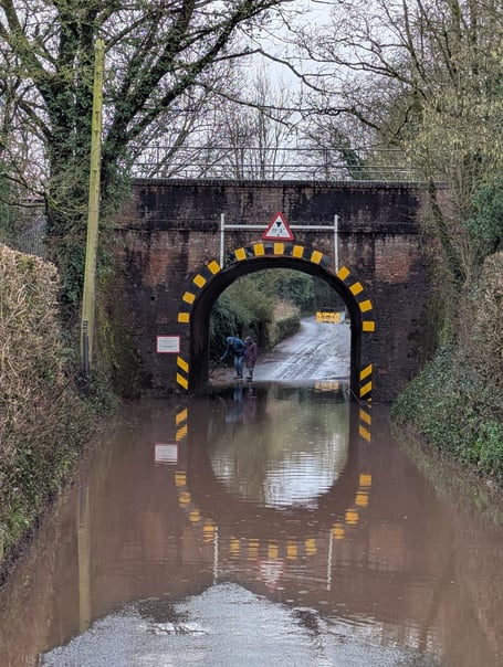
The road past the Lidl supermarket in Wellington to Nynehead has been cut off by a flood beneath the mainline railway bridge for the past fortnight.
Villagers have been left without their main access to reach the town, and without any sign of a solution.


Other roads serving Nynehead have also been hit by widespread flooding since the end of January, meaning villagers have had to search daily for acceptable alternative routes.
However, the diversions have doubled the time for residents to travel between the village and Wellington, as well as to reach main roads and the M5 motorway.
Nynehead Parish Council chairman Cllr Jeremy Toye said puddles beneath the railway were not uncommon, but a deep and persistent flood was unusual.
Cllr Toye said: “The water does not appear to come directly from the River Tone as in other local flood spots, but looks to result from a combination of intense rainfall and blocked drains.
“Highways engineers and local farmers worked on the deepening flood at the end of the week but despite jetted gullies, the floodwater stayed in place.
“Local farmers say it has proved challenging to find an outlet for the water, even after pumping out a temporary pond in a field nearby.
“Draining the road water itself appears to present logistic difficulties.
“While efforts to clear the flood are appreciated, the prolonged duration of the flood means that residents are inconvenienced on a daily basis.
“Getting to work, schools, or shops for those leaving the village are matched by challenges facing medical and emergency services trying to reach needy people, particularly as many are of an advanced age.
“A number of businesses serving the area are also affected.”
The Met Office said up to half-an-inch of rainfall was expected widely on Monday, with some places experiencing more than an inch.
The Environment Agency said more River Tone flooding was possible with areas most at risk including roads near Hillfarrance and Bradford on Tone.
It said the River Tone from Clatworthy Reservoir to Currymoor, the Hillfarrance Brook, the Halsewater Stream, and other tributaries in the Tone catchment were most at risk.
Somerset Council’s highways department has been contacted for comment on the situation.
Comments
This article has no comments yet. Be the first to leave a comment.