REFERENCES to the summer of 1976 probably mean little to people born since then, but that was when we endured the longest period of sustained hot, dry weather in the 20th century. This year, those memories were revived by further heatwaves in August and the absence of significant rainfall.


With a light breeze from the north, Friday, August 1, was sunny but relatively cool. The next two days were similar, but then, as Storm Floris crossed northern Scotland, Monday was windy with some light rain about midday, but the rest of the week was dry with variable amounts of sunshine and temperatures on the rise.
Monday, August 11, began with strong sunshine and hardly a breath of wind, the temperature in Wellington reaching 28°C (82F) before noon. Clouds formed after lunch and the atmosphere became oppressive, with thunderstorms seemingly imminent. For us, there were a few distant rumbles and a brief shower later that night. Tuesday, August 12, was even hotter, the maximum of 33°C (91.4F) matching the extraordinary heat we experienced in July.
Thankfully, the following day was cooler, and slightly damp first thing. Temperatures were however soon climbing once more, exceeding 28°C again on Friday, August 15, the weekend being very sunny and only slightly less hot. The new week began on a different note, with cloudy skies and a couple of spells of heavy drizzle. With a maximum temperature in Wellington of only 20°C (68F) on Monday, August 18, a remarkable sequence of fifty-five days with temperatures above 21°C (70F) came to an end. There was another shower of dirty rain in the small hours on Tuesday, August 19, the next day being cool and cloudy, before temperatures started to rise once more ahead of the bank holiday weekend.
A late burst of heat, with four days having temperatures above 25°C (77F), peaked on Monday, August 25. That day’s maximum of 27°C (81F) in Wellington was exceptional for so late in the summer. However, a depression positioned near Iceland, and containing the remnants of ex-Hurricane Erin, introduced an unsettled spell of weather. The long dry spell was properly ended by heavy rain in the small hours of Friday, August 29, the resulting 15mm (0.6 inch) being the most to fall in one day in Wellington since mid-April. Saturday, August 30, was decidedly autumnal as rain and drizzle drove in from the south-west, with some torrential showers the next day.
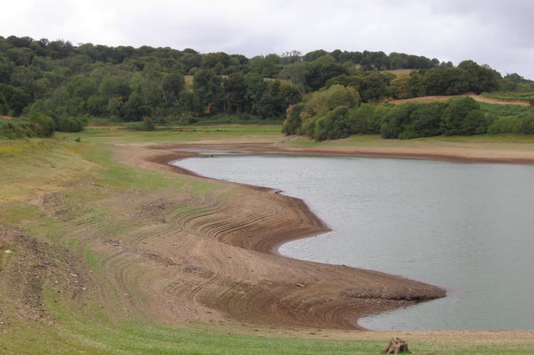
The month ended up as the fourth-warmest August on record, with a mean temperature of 18.0°C (64.4F). The summer as a whole was our warmest ever, dislodging 2018 from the top spot and relegating 1976 to fourth place. For the first time, temperatures above 30°C (86F) were recorded in June, July and August in this area. The summer has also been notably dry, with August’s rainfall total of 41mm (1.6 inches) being only 55 per cent of the average. Clatworthy Reservoir is now well below half full, so we need another wet autumn.
Comments
This article has no comments yet. Be the first to leave a comment.