
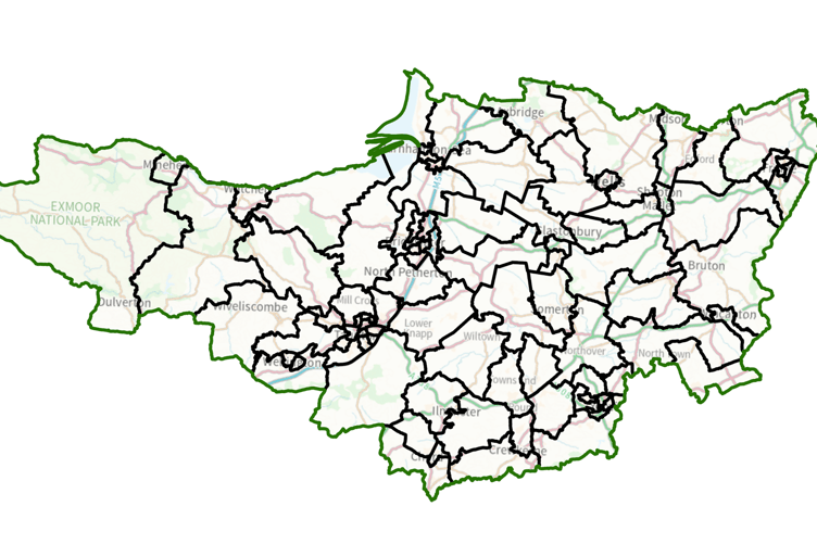
A NEW political map of the Wellington area was published by the Local Government Boundary Commission (LGBC) on Tuesday (March 3) showing the areas Somerset councillors will represent from the next elections in May, 2027.
Wellington currently has two urban councillors sharing all but the Cades, Priory, and Sylvan Road areas, with those residents having a councillor covering a ward which also stretches over the Blackdown Hills to Hatch Beachamp.
The commission’s focus in redrawing boundaries has been on reaching a position where each councillor represents a similar number of residents, rather than on community cohesion.
The result is that from next year Wellington will lose Rockwell Green, which will form a new division titled Monument with West Buckland, Sampford Arundel, Holywell Lake, and Wellington Without.


To make up electoral numbers, the commission has accepted a Wellington Labour Party proposal that the Monument division should also include people in the town living to the west of Swains Lane.
Tonedale, which the commission previously proposed to split off with Rockwell Green and Langford Budville, will now be part of Wellington West, while the east of the town comes back into Wellington as Wellington East.
Langford Budville, Bradford on Tone, and Oake will go into a division with Bishops Hull, while Cotford St Luke will join with Norton Fitzwarren.
Wiveliscombe will form one large rural division taking in also Milverton and most of what are known as the ‘10 Parishes’.
Villages on the Blackdown Hills, including Churchinford and Bishopswood, will be within a new Blackdown and Neroche ward which covers a substantial part of the rural area of the current Wellington East division.
The number of unitary councillors across Somerset will be cut from 110 to 96, each representing about 4,867 electors.
The changes will become law once Parliament has approved them.
Comments
This article has no comments yet. Be the first to leave a comment.