WEATHER warning fatigue was being risked across the Wellington and West Somerset areas as the UK Met Office issued yet another alert for heavy rain.
It was the third yellow weather warning issued by the Met Office in the past seven days and some residents were dismissive after previous alerts for severe wind and rain appeared to fizzle out and New Year’s Eve fireworks parties went ahead.
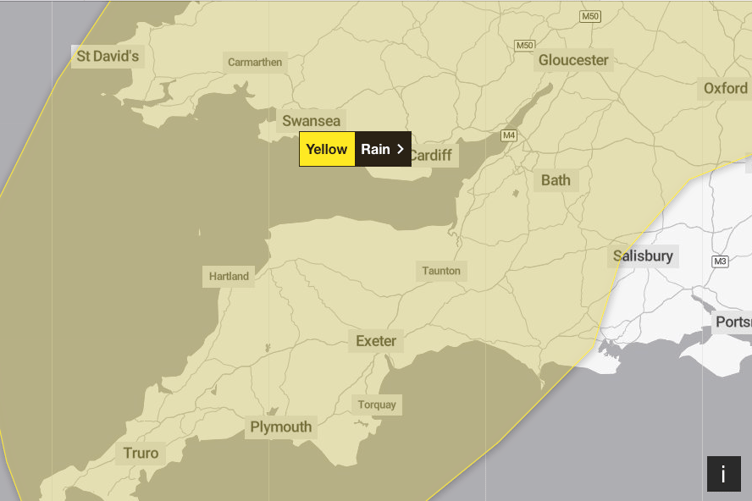
The latest alert was put in place for 5 pm on New Year’s Day until 9 pm on Tuesday (January 2).
A Met Office spokesperson said: “Following recent wet weather, further spells of rain, heavy in places, are expected on Monday evening and overnight.


“Then, after a brief gap, another spell of heavy rain is likely to spread northeastwards on Tuesday.
“The focus this evening and overnight will be across parts of South West and southern England, south Wales, and perhaps the Midlands.
“On Tuesday, the focus for the heaviest rain is less clear-cut but perhaps more likely across parts of Wales, the Midlands towards eastern England, and Yorkshire.
“Over the warning period, 15 to 30 mm (0.6-1.1 inches) rain is likely to fall fairly widely, with a few places seeing 35 to 50 mm (1.4-2 inches).
“Strong winds will affect parts of the area, with a separate wind warning in place.”
Similarly, the Environment Agency issued more flood alerts for West Somerset and Exmoor rivers and the Culm Valley.
Areas most at risk included the upper and middle River Exe from Exford to Exebridge and to Tiverton, the Rivers Barle, Lyn, Mole, and Bray and their tributaries, the Rivers Haddeo, Batherm, and Lowman, Horner Water, Rivers Aller and Washford, and the Hawkcombe, Monksilver, and Doniford Streams and tributaries.
The Rivers Culm and Clyst were a risk to Hemyock, Culmstock, and Uffculme, while the River Tone threatened flooding on the roads near Hillfarrance, Bradford-on-Tone, and Nynehead.
A flood alert was lifted on New Year’s Day for the West Somerset coastline between Gore Point and Hurlstone Point, including Porlock Weir.
Comments
This article has no comments yet. Be the first to leave a comment.