
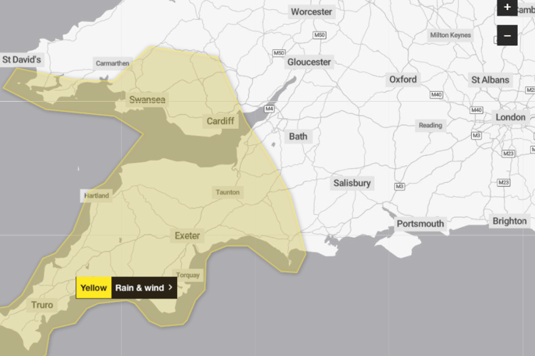
MORE yellow weather warnings have been issued for the Wellington area by the Met Office, making four days this week where alerts have been issued for rain and wind.
Tuesday (January 22) saw a 12-hour alert with warnings that wind gusts could reach 65 mph in exposed areas and heavy rain would - and did - cause localised flooding.
Thursday’s warning covered 8 am to 4 pm with more than three-quarters of an inch of rain forecast in short period some areas.
A Met Office spokesperson said: “The heaviest of the rain will clear northeastwards by late afternoon.”


Then, more warnings followed for Friday and Saturday with the approach of Storm Ingrid, which was given its name by Portugal’s weather service.
The spokesperson said: “Storm Ingrid will bring spells of heavy rain and strong winds across parts of South West England during Friday before easing on Saturday morning.”
They said an initial band of rain early on Friday could bring up to a further three-quarters of an inch of rain in places in a few hours, with this falling on already saturated ground.
A drier interlude was expected before further bands of locally heavy rain and showers pushing north into the area through the afternoon, evening, and overnight.
A similar amount of rain was expected to fall widely across the area by Saturday morning, with up to one-and-a-half inches possible in places.
The spokesperson said: “Given the saturated nature of the ground, this is likely to lead to some flooding.
“This second period of rain will be accompanied by strong winds and coastal gales, along with some very large waves.
“Gusts are widely expected to be 45 to 50 mph inland and up to 60 mph near coasts, with winds peaking during Friday evening before gradually easing overnight and into Saturday morning.”
The spokesperson advised people to check if their property could be at risk of flooding and, if so, think about preparing a flood plan and an emergency flood kit.
They said: “Give yourself the best chance of avoiding delays by checking road conditions if driving, or bus and train timetables, amending your travel plans if necessary.
“People cope better with power cuts when they have prepared for them in advance.
“It is easy to do, consider gathering torches and batteries, a mobile phone power pack, and other essential items.
“If you are on the coast, stay safe during stormy weather by being aware of large waves.
“Even from the shore, large breaking waves can sweep you off your feet and out to sea.
“Take care if walking near cliffs, know your route, and keep dogs on a lead.
“In an emergency, call 999 and ask for the Coastguard.
“Be prepared for weather warnings to change quickly.
“When a weather warning is issued, the Met Office recommends staying up to date with the weather forecast in your area.”
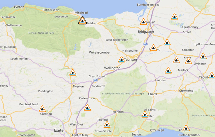
Environment Agency flood warnings were also in place for rivers across the area.
They included the River Tone and its catchment area from Clatworthy Reservoir to Currymoor, the Hillfarrance Brook, the Halsewater Stream, and other tributaries.
A spokesperson said: “River levels are expected to remain high from previous days’ rain and further rain forecast.
“Flooding is possible throughout Thursday and overnight into Friday.
“Low lying land and roads are expected to be most affected, particularly areas and roads around Hillfarrance, Bradford on Tone, Lane End Road at Ham and the Creech St Michael to Henlade road.
“Unsettled conditions with some heavy spells of rain are forecast for the coming days and rivers are expected to respond to this.
“We continue to monitor rainfall and river levels closely, and field teams are out clearing debris screens and checking rivers for blockages.”
On the Blackdown Hills and in the Culm Valley, the Rivers Clyst and Culm and their tributaries were liable to flooding which could affect Hemyock, Culmstock, and Uffculme.
The spokesperson said the rivers catchment areas were ‘sensitive’ after recent heavy rainfall.
They said: “We are closely monitoring the situation.
“Please avoid using low lying footpaths and bridges near local watercourses, and avoid walking, cycling, or driving through flood water.”
Comments
This article has no comments yet. Be the first to leave a comment.