
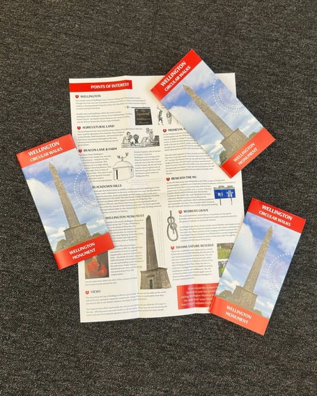
ON the back of the success of walking tours in Wellington, the Town Council has decided to produce its own walk map.
The Wellington Circular Walks map offers a walk from the centre of the town out through the local countryside to Wellington Monument and back taking in significant landmarks.
The Town Council map takes walkers on a 5.5 mile loop leaving from the North Street car park out to the Monument on the Blackdown Hills via Wellesley Park, over Oldway Road, through Little Silver Lane and along Beacon Lane.
A short history of the Wellington Monument accompanies a description of what to look out for in the distance before the map leads walkers on an alternative route back to the town via Park Farm, Oldway Road and Swains Lane and back to the car park.
Points of interest along the route are highlighted in the leaflet including the history and heritage of the local area. The walking route is suitable for adults, older children and well-behaved dogs.
A spokesperson for Wellington Town Council said: “Throughout the summer, we had quite a few visitors coming into our reception looking for local info and walking routes.
“While we have some lovely routes within the town itself, people let us know they were interested in exploring some of the surrounding countryside.
“Walking up to Wellington Monument is something of a right of passage in our town, so we thought this would be a great route to start with."
Copies of the map can be collected from the town council reception at 30 Fore Street.
 Police swoop on M5 near Wellington sees arrest of suspected illegal migrants
 Hundreds sign protest petition against housing plans on fields outside Wellington
 Case dropped against suspect in Wellington town centre early hours rape inquiry
 Pair arrested on suspicion of drug-driving as eight vehicles collide on fog-bound M5
The council is also working on two further routes and would welcome comments from the public on where they should go and what they should include.
Comments
We've recently changed our login process. If you have an account for commenting, you will need to re-register on the login window.
This article has no comments yet. Be the first to leave a comment.